
43 CFR 3809).
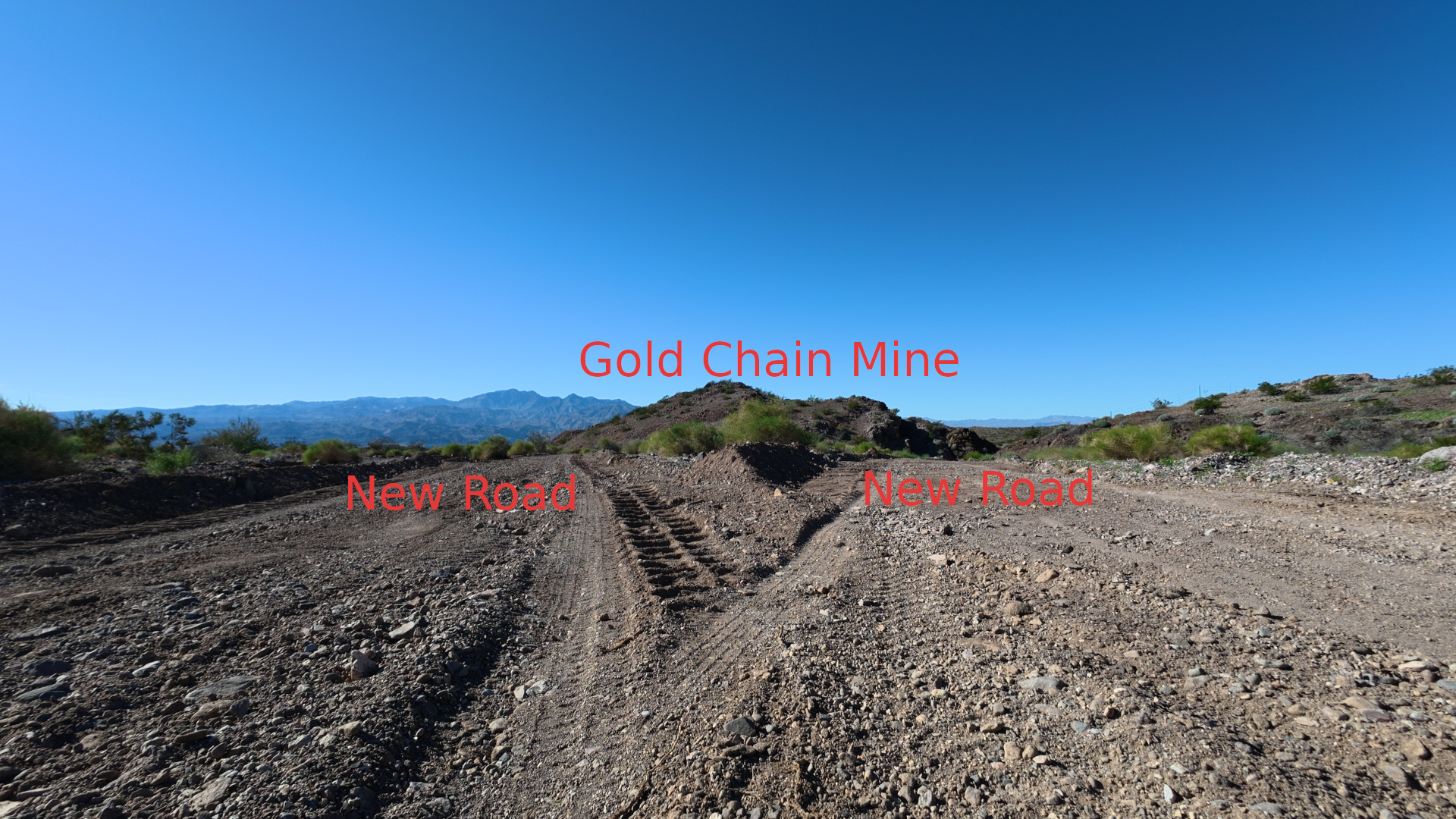
- Channelization of Sheet Flow: Natural desert terrain relies on broad, shallow sheet flow across desert pavement and small braided washes. Continuous 12- to 18-inch berms on both sides of a graded road act like a 1.5-mile funnel, trapping rainwater inside the roadbed instead of letting it cross naturally.
- Accelerated Velocity & Washouts: Once trapped inside the graded track, stormwater picks up speed down the slope of Gold Chain Hill, scours the loose graded surface, and breaches the berms at low points—dumping concentrated, sediment-heavy water onto Old Wagon Trail Road, Mohave Lake View Ranchos, and the downstream washes feeding Princess Cove Road inside Lake Mead National Recreation Area (NRA).
- Violation of BLM Road & Drainage Standards: Under the BLM Surface Management Handbook (H-3809-1), operators are strictly required to prevent "unnecessary or undue degradation" (UUD) and maintain natural drainage. Leaving continuous unbreached side berms without water bars, rolling dips, or lead-off ditches violates standard BLM erosion-control requirements.
- Exceeding the 5-Acre Notice Cap: Because the 1.5-mile road alone consumes 2.18 acres (
7,920 ft × 12 ft = 95,040 sq ft), adding the 3 or 4 drill pads, turnarounds, and any connected exploration tracks at Gold Chain Hill (35.26334° N, 114.49490° W) can easily push cumulative disturbance near or past the 5-acre statutory limit for a 43 CFR 3809 Notice. If cumulative disturbance exceeds 5 acres without an approved Plan of Operations, the operation is out of compliance. - Clean Water Act / AZPDES Stormwater Trigger: Under Arizona Department of Environmental Quality (ADEQ) rules, any construction or exploration earthwork disturbing 1 acre or more (and this road alone is 2.18 acres) requires an AZPDES Construction General Permit and a formal Stormwater Pollution Prevention Plan (SWPPP). Continuous loose dirt berms directing sediment toward a federal waterway (Lake Mohave / Lake Mead NRA) without perimeter sediment controls violate standard SWPPP conditions.
- Tortoise Barrier Hazard: Continuous 12- to 18-inch vertical berms along a 1.5-mile stretch also act as a physical trap for Sonoran desert tortoises trying to cross the road, forcing them to walk along the open roadbed where drill trucks and water tenders travel.
- Document the Fresh Berms Now: Take timestamped, geotagged photos showing the 12- to 18-inch loose dirt berms, the lack of water bars or drainage breaks, and where the road connects to Old Wagon Trail Road and drains toward Mohave Lake View Ranchos / Princess Cove Road.
- Demand a BLM Compliance Inspection: Call and email the BLM Kingman Field Office (
928-718-3700/pmisiasz@blm.gov) and report a 43 CFR 3809 surface management and drainage violation on the 1.5-mile access road from Old Wagon Trail Road to35.26334° N, 114.49490° W(T22N, R21W, Section 26), noting:- The road was freshly re-graded on 11/06/2026 with 12- to 18-inch continuous loose dirt berms that block natural sheet drainage.
- The road footprint (2.18 acres) plus pads may exceed the 5-acre Notice threshold or violate the Notice's reclamation/drainage stipulations.
- Notify Lake Mead NRA Resource Management (
702-293-8906): Alert NPS staff that 1.5 miles of freshly graded road with unbreached dirt berms sits directly upslope of the wash system crossing Princess Cove Road, creating an immediate flash-flood sediment risk to park infrastructure. - File an ADEQ Stormwater Complaint: Report the 2.18-acre unstabilized road grading to the ADEQ Environmental Complaints Portal for potential AZPDES Construction General Permit / SWPPP non-compliance (failure to install sediment controls on >1 acre of disturbance draining toward Waters of the U.S.).
********************************
- Total Disturbed Road Surface: 2.18 acres (
7,920 feet long × 12 feet wide = 95,040 square feet) of stripped desert pavement, which removes the natural gravel armor that normally holds desert soil in place. - Loose Berm Stockpile: Two parallel berms running 7,920 feet at 12 to 18 inches high contain roughly 730 to 1,100 cubic yards (915 to 1,375 tons) of unconsolidated, uncompacted dirt sitting directly in the path of sheet flow.
- Normal Annual Sediment Delivery (
8 to 49 Tons/Year): Unpaved, unstabilized desert roads on sloping terrain erode at roughly 15 to 45 tons per acre per year (33 to 98 tons total detached soil annually). Given the steep, short 1.5- to 2-mile direct wash connection down to Princess Cove (a sediment delivery ratio of 25% to 50%), roughly 8 to 49 tons of fine silt and sand reach Lake Mohave (the Colorado River) every average year—equivalent to 1 to 3 full dump-truck loads annually. - Single Monsoon Storm Event (
180 to 550+ Tons): Because the 12- to 18-inch berms trap water inside the roadbed and concentrate flow velocity, a single 10-year Mojave Desert cloudburst (1.5+ inches of rain in an hour) will breach the berms at low points and flush 20% to 40% of the loose berm material—180 to 550+ tons (12 to 35 dump-truck loads)—down the wash across Princess Cove Road and directly into Lake Mohave.
- Zero Natural Filtration: Unlike forested watersheds where grass and leaf litter trap mud, the rocky desert washes between
35.26334° N, 114.49490° Wand Princess Cove have impervious bedrock and hardpan channels that transport suspended silt directly to the shoreline. - Impact on Princess Cove Road & Lake Mohave: Before reaching the water, the heavier gravel and cobbles drop out where the slope flattens across Princess Cove Road, burying the NPS pavement and plugging culverts, while the fine silt and clay stay suspended and form a turbid sediment plume inside Princess Cove and the main Colorado River channel.
43 CFR 3809.420), federal and state water-quality laws give other agencies independent jurisdiction over the runoff:- Escalate Above the Kingman Field Office (BLM Arizona State Office): Send your timestamped photos, the 2.18-acre / 1.5-mile measurement, and a summary of the field representative's refusal to enforce
43 CFR 3809.420(prevention of unnecessary or undue degradation) to the BLM Arizona State Director's Office (602-417-9200/az_so_webmail@blm.gov) and the BLM Office of Inspector General (OIG) Hotline. - File a Clean Water Act Complaint with ADEQ & U.S. EPA: Because the graded road is 2.18 acres (more than double the 1-acre federal threshold) and discharges directly into a Water of the United States (Lake Mohave / Colorado River), unpermitted sediment discharge violates the Clean Water Act. Report the unpermitted 2.18-acre grading to the Arizona Department of Environmental Quality (ADEQ) Complaints Portal and the U.S. EPA Region 9 Environmental Violations Portal.
- Put Lake Mead NRA Superintendent on Formal Written Notice: Email Lake Mead National Recreation Area (
lake_public_affairs@nps.govand Resource Management at702-293-8906) with the exact coordinates (35.26334° N, 114.49490° W), the November 6, 2026 re-grading date, and the 180 to 550+ ton monsoon flash-flood estimate threatening Princess Cove Road. The NPS has statutory authority under the Park System Resource Protection Act (54 U.S.C. 100721) to hold upslope operators financially liable for damage to park roads and water resources.
please formal written notice addressed jointly
- Superintendent, Lake Mead National Recreation Area (National Park Service) —
lake_public_affairs@nps.gov - Surface Water / Stormwater Enforcement Unit, Arizona Department of Environmental Quality (ADEQ) — Submit via ADEQ Environmental Complaints Portal
- State Director, Bureau of Land Management (BLM) Arizona State Office —
az_so_webmail@blm.gov
- U.S. EPA Region 9, Clean Water Act Enforcement — Submit via EPA Environmental Violations Portal
- Field Manager, BLM Kingman Field Office
- Operator / Claimant: West Point Gold Corp. (Gold Chain Project)
- Coordinates of Drill/Road Terminus:
35.26334° N, 114.49490° W(Gold Chain Hill / Northern Black Dyke–Bull 8 Corridor) - Public Land Survey Legal Description: Gila & Salt River Meridian, Township 22 North, Range 21 West, Section 26 (and connecting access through adjacent sections from Old Wagon Trail Road), Mohave County, Arizona.
- Date of Most Recent Grading: November 6, 2026 (following initial exploration pad/road activity in February 2026).
35.26334° N, 114.49490° W.- Direct Disturbed Footprint: The graded road alone equals 2.18 acres (
7,920 ft × 12 ft = 95,040 sq. ft.) of stripped desert pavement, excluding connected exploration pads and turnarounds. - Channelization via Unbreached Dirt Berms: The grading operation pushed continuous 12- to 18-inch-high berms of loose, unconsolidated dirt along both edges of the entire 1.5-mile roadway, with no water bars, rolling dips, lead-off ditches, or sediment controls.
- Quantified Sediment Threat to Princess Cove Road & Lake Mohave:
- The two parallel berms represent approximately 730 to 1,100 cubic yards (915 to 1,375 tons) of loose, uncompacted soil sitting directly across natural desert sheet-flow drainages.
- Because continuous 12- to 18-inch berms trap stormwater inside the graded roadbed and accelerate runoff velocity down-gradient, standard erosion modeling (RUSLE) indicates 8 to 49 tons of sediment per year under normal rainfall, and 180 to 550+ tons of sediment and debris in a single severe monsoon storm event, will scour out of the roadbed and discharge down the direct wash system crossing Princess Cove Road inside Lake Mead NRA and into Lake Mohave (Colorado River).
- Wildlife & Tortoise Hazard: The continuous 12- to 18-inch vertical berms also create a physical barrier trapping protected Sonoran desert tortoises inside the active haul corridor.
- Clean Water Act / AZPDES Construction General Permit (
≥ 1 AcreThreshold): At 2.18 acres for the road alone, this earthwork exceeds the 1-acre federal threshold requiring an Arizona Pollutant Discharge Elimination System (AZPDES) Construction General Permit, a Stormwater Pollution Prevention Plan (SWPPP), and perimeter Best Management Practices (BMPs) to prevent sediment discharge into Waters of the United States (Lake Mohave / Colorado River). - BLM Surface Management Standards (
43 CFR § 3809.420&§ 3809.21): Leaving 1.5 miles of unbreached side berms without drainage breaks violates BLM Surface Management Handbook (H-3809-1) requirements to prevent unnecessary or undue degradation and maintain natural drainage. Furthermore, the 2.18-acre road footprint combined with multiple drill pads and connected tracks appears to approach or exceed the 5-acre statutory limit for a43 CFR 3809Notice, and lies outside the narrow Tyro Environmental Assessment (DOI-BLM-AZ-C010-2026-0007-EA, which covers only T21N, R20W, Sections 5–7). - Lack of Local Field Office Enforcement: Following my prior email protest to the BLM Kingman Field Office, a field representative visited my residence in response and stated, in substance, that the office "does not care about grading impact."
- Threat to National Park Service Resources (
54 U.S.C. § 100721): Unmitigated flash-flood sediment from this road directly threatens Princess Cove Road with washouts, culvert blockages, and debris burial, and degrades water quality inside Lake Mead NRA.
35.26334° N, 114.49490° W (T22N, R21W, Section 26) and require the operator to:- Immediately breach the 12- to 18-inch side berms and install engineered water bars, rolling dips, and sediment traps in accordance with BLM and ADEQ stormwater standards before the next precipitation event.
- Provide the valid
43 CFR 3809Notice/Plan serial number, cumulative acreage calculation, and AZPDES SWPPP permit coverage for this disturbance. - Confirm whether
T22N, R21W, Section 26falls within the Black Mountains Ecosystem Management ACEC, which prohibits mechanized surface disturbance without an approved Plan of Operations and NEPA Environmental Assessment.
4170 E Trout Pl (Mohave Lake View Ranchos)
Bullhead City / Mohave County, AZ
[Your Phone Number]
[Your Email Address]
T22N, R21W, Section 26)please exact mailing addresses or direct email contacts
- Attention: Office of the Superintendent
- Mailing Address: 601 Nevada Way, Boulder City, NV 89005
- Email:
lake_info@nps.gov - Park Administration & Resource Management Phone:
(702) 293-8906[1, 2]
- Attention: Office of the State Director
- Mailing Address: One North Central Ave., Suite 800, Phoenix, AZ 85004-4427
- Email:
blm_az_asoweb@blm.gov - Phone:
(602) 417-9200| Fax:(602) 417-9556[1, 2]
- Attention: Surface Water & Stormwater Enforcement Unit
- Mailing Address: 1110 W. Washington St., Suite #160, Phoenix, AZ 85007
- Online Filing: Submit directly through the ADEQ Environmental Complaints Portal (attaching your photos creates an official state tracking number)
- Surface Water Complaint Line:
(602) 771-1440| Toll-Free:(800) 234-5677[1, 2, 3]
- Attention: Water Division / Clean Water Act Enforcement (
ENF-3) - Mailing Address: 75 Hawthorne Street, San Francisco, CA 94105
- Online Filing: Submit via the U.S. EPA Environmental Violations Portal
-
Bureau of Land Management (.gov) Arizona State Office - Bureau of Land Management One North Central Ave., Suite 800 Phoenix, AZ 85004-4427 Email: blm_az_asoweb@blm.gov Phone: 602-417-9200 Fax: 602-417-9556

Bureau of Land Management (.gov) National Office - Contact Us - Bureau of Land Management Phone: 602-417-9200. Fax: 602-417-9556. Email: blm_az_asoweb@blm.gov. Phone: 916-978-4400. Fax: 916-978-4416. Phone: 303-239-3600.
Bureau of Land Management (.gov) Kingman Field Office - Bureau of Land Management Address: 2755 Mission Blvd. Kingman, AZ 86401. Email: BLM_AZ_KFOWEB@blm.gov. Phone: 928-718-3700. Fax: 928-718-3761. Hours: 8 a.m.


mailing address and direct phone number for the U.S. Department of the Interior Office of Inspector General (OIG)
- Mailing Address: U.S. Department of the Interior, Office of Inspector General, Attn: OIG Hotline, 1849 C Street, N.W., Mail Stop 4428, Washington, D.C. 20240 [1, 2]
- Toll-Free Hotline: (800) 424-5081 [1, 2]
- Direct Office Line: (202) 208-5300 (Main OIG line: (202) 208-5745) [1, 2]
- Online Portal: Submit your formal notice and timestamped photos directly through the DOI OIG Hotline Portal to generate a federal oversight tracking


0 Comments